Study charts 52 per cent decline of tidal wetlands in Kanamaluka / Tamar estuary
18 September 2025
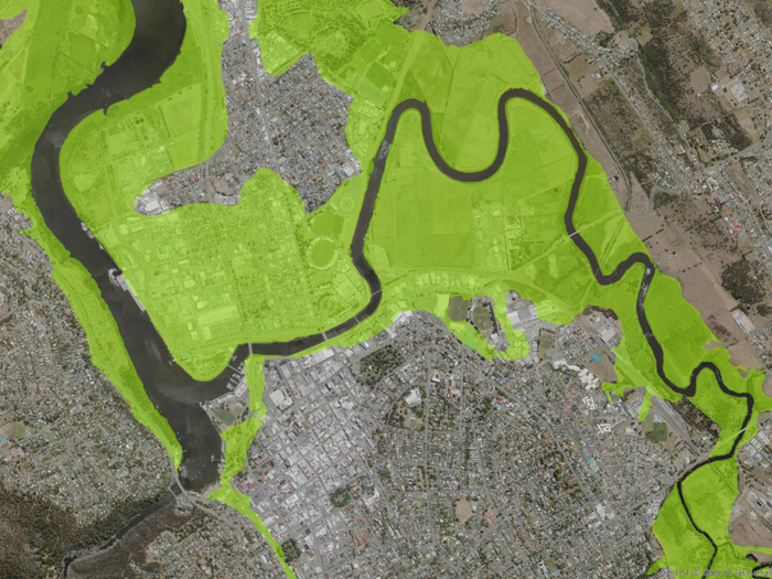
The area shaded in lime-green is the post-colonisation extent of wetlands surrounding Launceston. The image reveals the degree to which Launceston’s northern suburbs are located on what was once wetland in the early 1800s.
A new study has revealed more than half of the tidal wetland habitat in the Kanamaluka / Tamar estuary has been lost since the European colonisation of Tasmania.
By analysing historical sketches, surveys and notes dating back to as early as 1809, along with the earliest available aerial photography (circa 1945 to 1947) and natural clues called environmental proxies, this study has produced the most detailed and comprehensive map of the historical post-colonisation (i.e. shortly after European occupation) spatial extent of tidal wetlands along the entire estuary.
The study, commissioned by the Tamar Estuary and Esk Rivers (TEER) Program, was undertaken by a team of researchers at the University of Tasmania’s School of Geography, Planning, and Spatial Sciences, led by Joshua Briggs and wetland ecologist Dr Vishnu Prahalad.
Dr Prahalad said the team calculated that more than 200 years ago, and prior to infill and hydrological interference, the estuary supported the largest regional expanse of emergent tidal wetlands in Tasmania, covering about 2,231 hectares. Today, the area has been reduced to just 1,074 hectares, excluding invasive rice grass (Spartina anglica) marshland and drained wetlands, representing a net loss of 52 per cent.
“Understanding how much wetland habitat we’ve lost, and where that loss has occurred, offers us a lens to the past. This hindsight is important in guiding present-day monitoring and reporting efforts, and for shaping conservation and restoration goals,” said Dr Prahalad.
“For example, much of the wetlands that occurred around the settlement of Launceston have been permanently lost, but there may be pockets that could still be recovered and rehabilitated. This provides us with an exciting opportunity to create diverse and thriving wetland areas similar to those found at Tamar Island close to the heart of the city.”
TEER Program Manager, Dr Michael Murunga, said while there have been previous efforts to map the extent of wetland communities bordering the Kanamaluka/ Tamar estuary, most notably a 2014 NRM North-funded project also led by Dr Prahalad, those earlier studies did not quantify the extent of spatial change over time, as they did not establish a post-colonisation baseline.
“Understanding spatial change is important because tidal wetlands extent - as mapped by the study - provides an additional indicator of estuarine health alongside existing long-term water quality monitoring undertaken by the TEER Program,” Dr Murunga said.
“Wetlands are invaluable for both wildlife and humans. The Tamar Island Wetlands, in particular, are recognised internationally as a Key Biodiversity Area and an Important Bird Area, providing crucial habitat, food, and shelter for native species as well as migratory bird species that come from as far away as Siberia and Alaska.
“Healthy wetlands provide essential ecosystem services, such as water purification, carbon storage and sequestration, and flood control. They are also naturally beautiful, and time spent in these environments has been shown to enhance mental well-being.”
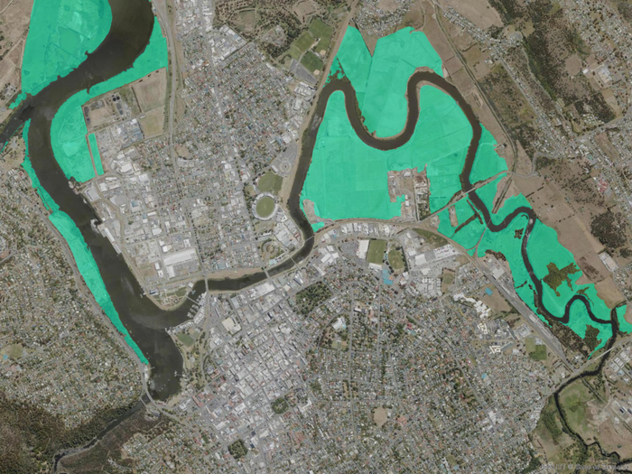
The area shaded teal shows the present-day extent of wetlands surrounding Launceston. Losses highlight the need to protect remaining wetland patches and look for rehabilitation opportunities.
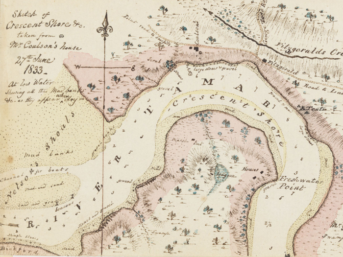
An example of a historical sketch used in the study. This map of the Crescent Shore was drawn at low water depicting target features including marsh, swamp and tea tree scrub (Scott 1833).
Dr Prahalad said he hoped the study would foster the necessary social license and community enthusiasm for further wetland rehabilitation projects, such as the North Esk River trial wetland restoration project being led by the Tamar Estuary Management Taskforce (TEMT), as part of its 10-year vision for the Kanamaluka / Tamar estuary.
“The North Esk River trial wetland restoration project is a timely and important initiative, especially in the light of the study’s findings. It could also serve as a useful model for rehabilitating other degraded wetland areas along the estuary foreshore,” Dr Prahalad said.
“Launceston has the opportunity now of reviving some of these lost wetlands. Doing so not only helps with flooding and sedimentation issues but also opens possibilities for tourism and recreation that draws upon Tasmania’s ‘Natural State’ brand identity. Our study helps in offering a ‘mud map’ of where this wetland revival is feasible right across the estuary.”
The study, entitled An Adaptive Multiple‑Criteria Decision Analysis Approach to Mapping Regional‑Scale Post‑Colonisation Changes to the Tidal Wetlands of Kanamaluka/River Tamar, Tasmania, Australia was published in April 2025 in the journal Estuaries and Coasts and is freely available online.
More information: https://www.teer.org.au/wetlands